|
|
|
|
Shiver under moonlight in the splendid Bale Mountains, swelter politely, slack-jawed in a Mursi village or silently savour the spotting of a rare bird. Known for its rich natural attractions, southern Ethiopia proffers captivating wildlife, scenic landscapes, great trekking possibilities and some of the continent’s most diverse and fascinating people.
The south west’s Omo region has been called ‘ Africa’s last great wilderness’, and is home not just to Ethiopia’s few remaining large mammals including lion and elephant, but also its last isolated tribes, including the famous Mursi lip stretchers and body-painting Karo.
Africa’s renowned Rift valley cuts through the south and hosts
lakes, astounding birdlife, national parks and wildlife
sanctuaries.
East of the rift, the Bale Mountains tower over the
surrounding pastures of the Oromo people. Within these peaks
is one of Africa’s largest mountain park. The Bale Mountains
National park is the best place in Ethiopia to see endemic
wildlife, including the endangered Ethiopian Wolf. Trekking in
the mountains, in the rain, among the heather, is fantastic.
HIGHLIGHTS OF SOUTHERN ETHIOPIA
PEOPLE’S OF OMO VALLEY
![]() Tsemai
Tsemai
The Tsemai, the dominant people of Weito village on the
Konso-Jinka road, are regarded to be among the least known
ethnic groups of Ethiopia. Estimated to be a total of some
5000 people, their territory extends along the western bank of
the Weito River, known in Tsemai as the Dulaika River. They
are mixed subsistence farmers who practice flood cultivation,
with the major crops being sorghum and maize. They also rear
livestock, especially cattle, and keep beehives for honey. The
Tsemai speak an Omotic language with an influence of Eastern
Cushitic language that is closely related to the one spoken in
Konso, which, according to oral tradition, is from where their
founding chief Asasa originated. The present chief, who lives
at the long-standing Tsemai capital of Ganda Bogolkila, is
claimed to be the ninth in line after Asasa, suggesting that
this migration might have happened between 150 and 250 years
ago.
Although their appearance and dress style is similar to that
of the Omotic Ari people, the Tsemai share closer political
and spiritual affiliations with the Erbore, who speak a
similar language, and whose territory lies adjacent to the
Tsemai chief’s village. The Tsemai also frequently and openly
intermarry with the Hammer, whose territory lies immediately
west of theirs. In common with many other people of southern
Ethiopia, society is structured around and age set system.
Four fixed age sets are recognized, with every set graduating
in seniority once a decade, when a new generation of boys
between the ages of about 11 and 22 is initiated.
![]() Erbore
Erbore
Although relatively large, Erbore is far more rustic and
unaffected than many similarly sized towns in South Omo, with
the police station on its outskirts more-or -less the only
building that isn’t constructed along traditional lines.
In common with their linguistically and culturally affiliated
Tsemai neighbors, the Erbore migrated to their present
homeland from Konso perhaps two centuries ago. Because they
have ancestral and cultural links to Konso and the
pastoralists of the surrounding lowlands, the Erbore
traditionally played an important role as middlemen in trade
between the Omo River and the Konso Highlands.
The town of Erbore lies in and area where several tribal
boundaries converge, and because the Erbore people routinely
intermarry with other ethnic groups like the Guji and Borena
Oromo, The Hammer and the Tsemai. It is also inhabited by a
substantial number of Hammer and even Borena women – adding a
cosmopolitan feel to the worthwhile Saturday market.
![]() Dasenech
Dasenech
The Dasenech, alternatively known as the Geleb or Galeba,
Marille and Reshiat, live just north of Lake Turkana, the
region where Ethiopia borders Kenya and Sudan. These names all
concern the same people, in total 24.000 souls. The Dasenech
are neighbored by Turkana and Bume and are Ethiopia's most
southern people.
The Dasenech can however be divided in eight clans. These are
the Elele (ca. 6,000 people), Inkabelo (8,000), Inkoria
(3,000), Koro (700), Naritch (3,000), Oro (1,000), Randal
(1,000), and Ri'ele (600). Two of them (Inkabelo and Inkoria)
come forth from the same ancestors: the Nyupe tribe in
West-Kenya, also called the Pokot. These have more or less
assimilated the Naritch (probably a splinter group of the
Murle of Western Ethiopia) and the Oro. The Oro historically
probably have had the dominating language and are solely
responsible for the Kushite language now spoken by all
Dasenech. The river people Ri'ele seem to have Borena
background but have been Dasenech as time went by. The Randal
are connected historically with the Rendille of Northern
Kenya, whereas the Koro are related to the Maasai of Lake
Turkana's west coast. Having contemplated this information it
will not be hard to understand that the Dasenech aren't a
united people, but more like a cluster of small groups with
shared language, land, and rituals.
All clans have a more or less defined territory, except for
the Koro and Oro, who are semi-nomadic. The Inkabelo are the
wealthiest Dasenech and occupy the best land (Oro and Koro
actually travel around in Inkabelo land). One other thing
worth mentioning is that all Dasenech seem to have natural
antipathy against fish. Eating fish is really a last resort in
times of crises. The most important ritual of the Dasenech is
the so-called dime. Taking part in the dime ritual are those
men who have daughters that have already reached puberty.
After the ceremony, which takes six weeks, the participants
are upgraded to 'great men', or those that may engage in
politics. The dime ritual is directly connected to the
upcoming marriage of the daughters and consists for the larger
part of slaughtering large quantities of cattle (per
participant: 10 cows, 30 sheep and/or goats). By the end of
the ceremony the participants are extremely well-dressed, with
ostrich feathers in their clay hair, oxtails around their
arms, leopard skin over their shoulders, as well as the same
skirt they wore during their circumcision many years earlier.
In their hands they will carry wooden shields and a stick with
a fallus symbol.
The nomadic roots of the Dasenech are most clearly seen today
in their traditional villages, comprised as they are of small,
flimsy, domed huts strongly reminiscent of the impermanent
structures built by other African desert pastoralists, from
the Tuareg of the Sahara to the Nama of the Kalahari. One such
village lies on the west bank of the Omo, practically opposite
Omorate, and can be reached by utilizing the flat-bottomed
boat that serves as a ferry across the river (police escort
mandatory) Another similar village lies about 20 minutes’ walk
south of the town center on the east bank of the river.
![]() Bome
Bome
The Bume are also known as the Nyangatom. the Bume live west
of the Dasenech people, south- west of the Karo people, south
of the Surma people and North of the Ethio- Kenyan boundary.
They occasionally migrate into the lower regions of the Omo
national park when water or grazing is scarce.
Numbering around 6,000 in population, the Bume speak one of
the Omotic group languages - Nyangatom. They are agro-
pastoralists, relying on cattle herding and flood-retreat
agriculture (consisting mainly of sorghum harvesting on the
Omo and Kibish Rivers). In other words, they are semi-nomadic
hunters and cattle-herders by custom, measuring their wealth
in terms of the size of their herd, though flood agriculture
now plays and increasingly important role in their
subsistence. They tend to indulge in honey and frequently
smoke out beehives to get the honey inside the nests.
The Bume are known to be great warriors and, quite frequently,
active warmongers. Although they are peaceful and welcoming,
they conflict with the neighboring tribes including the
Hammer, the Karo and the Surma.
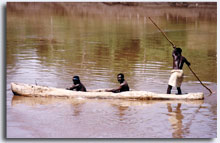
Kangate is the get way for accessing the habitation of the
Bume from the east of Omo River. The crossing of the Omo
river, although need to have time to do that) to the west
enables one to see their small hat villages well.
![]() Mursi
Mursi
The Mursi number about 5,000 and are primarily pastoralists
categorized in the Nilo-Saharan language family. The Mursi are
Known for their lip plate tradition; an unmarried woman's
lower lip will be pierced and then progressively stretched
over the period of a year. A clay disc indented like a pulley
wheel is squeezed into the hole in the lip. As it stretches,
ever-larger discs are forced in until the lip, now a loop, is
so long it can sometimes be pulled right over the owner's
head. The size of the lip plate determines the bride price,
with a large one bringing in fifty head of cattle. The women
make the lip plates from clay, color them with ochre and
charcoal, and bake them in a fire. Stick fighting or "donga":
At a fight, each contestant is armed with a hardwood pole
about six feet long with a weight of just less than two
pounds. In the attacking position, this pole is gripped at its
base with both hands - the left above the right, in order to
give maximum swing and leverage. Each player beats his
opponent with his stick as many times as possible with the
intention of knocking him down and eliminating him from the
game. Players are usually unmarried men. The winner is carried
away on a platform of poles to a group of girls waiting at the
side of the arena, who decide among themselves which of them
will ask for his hand in marriage. Taking part in a stick
fight is considered to be more important than winning it. The
men paint their bodies with a mixture of chalk and water
before the fight.
![]() Benna
Benna
Broadly speaking, the Benna belong to the Hamar-Bashada
cultural group. Numbering about 35,000 they are primarily
settled farmers living in the highlands to the east of the
Mago National Park. They enter the Park to hunt during the dry
season; if they manage to kill a buffalo they adorn them with
clay and have a celebration.
![]() Dorze
Dorze
Dorze is a tribe of skillful cotton weavers and potters who
live in the mountains just outside Arba Minch. Their houses,
standing up to 6 m tall and built in a shape of elephant's
head, are the most unique traditional structures in Africa.
Staple food of the Dorze tribe is enset or false banana. The
Dorze dwellings are entirely organic: they are built using
bamboo, grass, and false banana leaves. A visit to the Dorze
house is a pleasant and memorable experience for the tourists.
![]() Hamer
Hamer
Hamer is a tribe which occupies the large territory of South
Omo. They speak a language which belongs to the Omotic group
of languages and display an elaborate and unique style of body
decorations and clothes. Women wear leather skirts decorated
with cowri shells. Their braided hair is painted with ochre,
and their arms are decorated with 15 or more copper bracelets.
The most important event in the Hamer society is the Bull
Jumping Ceremony, the rite which marks a passage of men from
one age group to another. This ceremony can be attended by
tourists visiting the Hamer territory. Two principal
settlements of Hamer are Dimeka and Turmi, especially colorful
and interesting to visit on the market days.
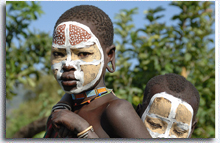
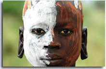
![]() Karo
Karo
Karo is a small tribe of perhaps 1000 people or less. They
live in the area of two small villages - Kolcho and Dus. Karo
are best known for their elaborate body paintings, special for
important ceremonies. Colorful face masks are prepared using
chalk, charcoal, iron ore, and yellow rock. Hairstyle of both
men and women is also very unusual. Foreign tourists are
always welcome to attend Karo traditional ceremonies if they
are lucky to visit their villages at such times.
![]() Konso
Konso
Konso is a tribe which inhabits the area of basalt hills about
85 km to the south from Arba Minch. They speak a Cushitic
language. Konso live in villages usually located on a top of a
hill and surrounded by a 2 m stone wall. Konso are famous all
over Ethiopia for their advanced methods of land cultivation,
ehich include irrigation and building of terraces. Also very
famous are the Konso's waqa - carved wooden monuments erected
on the graves.
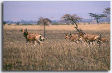
NATIONAL PARKS AND WILDLIFE SANCTUARIES
Offering splendid trekking, the rarest of mammals and hundreds
of bird species,
![]() BALE MOUNTAIN NATIONAL PARK: the
park stretches over 2400sq km and ranges in altitude from
1500m to 4377m. The Bale Mountain National Park is known for
their endemic wild life, particularly the Ethiopian Wolf and
the Mountain Nyla It’s also a home for Over 60 mammal species
and 260 bird species. Features steep ridges, alpine plateaus,
Ethiopian wolves, mountain Nyala and 16 endemic birds and its
best area for trekking and bird-watching.
BALE MOUNTAIN NATIONAL PARK: the
park stretches over 2400sq km and ranges in altitude from
1500m to 4377m. The Bale Mountain National Park is known for
their endemic wild life, particularly the Ethiopian Wolf and
the Mountain Nyla It’s also a home for Over 60 mammal species
and 260 bird species. Features steep ridges, alpine plateaus,
Ethiopian wolves, mountain Nyala and 16 endemic birds and its
best area for trekking and bird-watching.
![]() LAKE ABIATA-SHALA NATIONAL PARK:
west of Lake Langano lies the twins lakes of Abiata and Shala,
which form part of the 887sq km Lake Abiata-Shala National
Park. Identical twins these lakes are not. Shala’s 410sq km
surface sits within a collapsed volcanic caldera and depths
exceed 260m in some areas, while Abiata’s highly alkaline
waters rest in a shallow pan no more than 14m in depth.
Traditionally, fish thriving in Abiata’s waters fed storks,
cormorants and pelicans that bred in safety on volcanic
islands dotting shala’s surface.
LAKE ABIATA-SHALA NATIONAL PARK:
west of Lake Langano lies the twins lakes of Abiata and Shala,
which form part of the 887sq km Lake Abiata-Shala National
Park. Identical twins these lakes are not. Shala’s 410sq km
surface sits within a collapsed volcanic caldera and depths
exceed 260m in some areas, while Abiata’s highly alkaline
waters rest in a shallow pan no more than 14m in depth.
Traditionally, fish thriving in Abiata’s waters fed storks,
cormorants and pelicans that bred in safety on volcanic
islands dotting shala’s surface.
![]() MAGO NATIONAL PARK: not for the
pusillanimous, a visit to this 2162 sq km park is a two-footed
leap into true African wilds. Its more adventure than you can
shake a stick at! You will also have the chance to visit Mursi
villages along the Mago River and spot some animals too. one
thing is for sure, you will never forget your time here.
MAGO NATIONAL PARK: not for the
pusillanimous, a visit to this 2162 sq km park is a two-footed
leap into true African wilds. Its more adventure than you can
shake a stick at! You will also have the chance to visit Mursi
villages along the Mago River and spot some animals too. one
thing is for sure, you will never forget your time here.
![]() OMO NATIONAL PARK: if Mago
national park is for the adventurous, Omo National Park is for
the masochist’s. to state the obvious, travelling in
Ethiopia’s most remote park is incredibly tough. Travelling to
this park you have also to visit the villages of Mursi, Dizi
and Surma who lives in the park.
OMO NATIONAL PARK: if Mago
national park is for the adventurous, Omo National Park is for
the masochist’s. to state the obvious, travelling in
Ethiopia’s most remote park is incredibly tough. Travelling to
this park you have also to visit the villages of Mursi, Dizi
and Surma who lives in the park.
![]() NECHISAR NATIONAL PARK:
NECHISAR NATIONAL PARK:
 Spanning
the narrow, yet mountainous ‘Bridge of God’ that separates
Lakes Chamo and Abaya, Nechisar National Park ranks among the
most scenic parks in east Africa.
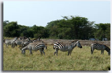
Although only 514 sq km, the park contains diverse habitats
ranging from wide-open savannah and acacia woodland to thick
bush and sections of riparian forest. The bleached savannah
grasses actually spawned the park’s name, which means ‘white
grass’ in Amharic. And you have a chance to see savannah,
acacia woodland, Burchell’s Zebras, Swayne’s, hartebeest,
crocodiles, great kudu, and 320 bird species.
Spanning
the narrow, yet mountainous ‘Bridge of God’ that separates
Lakes Chamo and Abaya, Nechisar National Park ranks among the
most scenic parks in east Africa.
Although only 514 sq km, the park contains diverse habitats
ranging from wide-open savannah and acacia woodland to thick
bush and sections of riparian forest. The bleached savannah
grasses actually spawned the park’s name, which means ‘white
grass’ in Amharic. And you have a chance to see savannah,
acacia woodland, Burchell’s Zebras, Swayne’s, hartebeest,
crocodiles, great kudu, and 320 bird species.
![]() SENKELE WILDLIFE SANCTUARY:
Originally established to protect the endemic Swayne’s
hartebeest, the open acacia woodlands of the Senkele Wildlife
Sanctuary also hosts Bohor reedbucks, greater kudus, spotted
hyenas, serval and civet cats, caracals, warthogs, common
jackals and oribi antelopes. The globally threatened Aquila
clanga ( greater spotted eagle) is one of 191 bird species
documented.
SENKELE WILDLIFE SANCTUARY:
Originally established to protect the endemic Swayne’s
hartebeest, the open acacia woodlands of the Senkele Wildlife
Sanctuary also hosts Bohor reedbucks, greater kudus, spotted
hyenas, serval and civet cats, caracals, warthogs, common
jackals and oribi antelopes. The globally threatened Aquila
clanga ( greater spotted eagle) is one of 191 bird species
documented.
With a population of approximately 450. The Swayne’s
hartebeest is the most easily spotted species in this 36sq km.
![]() YABELO WILDELIFE SANCTUARY:
YABELO WILDELIFE SANCTUARY:
 Covering an area of 2496 sq km, the Yabelo Wildlife Sanctuary
was originally created to protect the endemic Swayne’s
hartebeest. How over, it’s now better known for two truly
unique range-restricted bird species. Although commonly seen
within the sanctuary, the Stresemann’s bush crow and
white-tailed swallow are not found anywhere else in the world.
Why they never stray more than 100 km from here is still
anyone’s guess. The semi-endemic brown sawing is also found
here.
Covering an area of 2496 sq km, the Yabelo Wildlife Sanctuary
was originally created to protect the endemic Swayne’s
hartebeest. How over, it’s now better known for two truly
unique range-restricted bird species. Although commonly seen
within the sanctuary, the Stresemann’s bush crow and
white-tailed swallow are not found anywhere else in the world.
Why they never stray more than 100 km from here is still
anyone’s guess. The semi-endemic brown sawing is also found
here.
The 25 mammals species inhabiting the acacia woodland and
savannah grass include Burchell’s zebras, dik-diks, greater
and lesser kudus, gerenuks, and grant’s gazelles, all quit
commonly seen. The golden jackal and ostrich are sometimes
spotted.
RIFT VALLEY LAKES
With mysterious ancient stelae fields, numerous hot springs
and five unique Rift valley lakes hosting everything from
historical island monasteries to endangered birds, this
275km-long corridor is more than just a gateway to southern
Ethiopia.
![]() LAKE ZIWAY: surrounded by blue
volcanic hills, south of Addis Ababa, and covering a massive
425 sq km is Lake Ziway, the largest of the northern group of
Rift valley lakes. It is an attractive enough place, but its
best known for its Birdlife. White Pelicans, black egrets,
saddlebill, and yellowbill storks are all seen here, as well
as a variety of kingfishers and waterfowl.
LAKE ZIWAY: surrounded by blue
volcanic hills, south of Addis Ababa, and covering a massive
425 sq km is Lake Ziway, the largest of the northern group of
Rift valley lakes. It is an attractive enough place, but its
best known for its Birdlife. White Pelicans, black egrets,
saddlebill, and yellowbill storks are all seen here, as well
as a variety of kingfishers and waterfowl.
The lake is also home to five little volcanic islands, of
which three once boasted medieval churches. Tulu Gudo is home
to three monasteries. Debre Tsion, the most famous, has long
and enigmatic history. According to tradition, it once housed
the Ark of the Covenant.
![]() LAKE LANGANO: Lake Langano, set
against the 400m blue Arsi Mountains, is a dream comes true
for many Brits. They can do their swimming kit and cross
‘doing the back stroke in the world’s largest cup of English
tea’ off their list of fantasies- yes, langano’s water is on
the brown side. The birding is excellent on some of the more
remote sections of this 300sq km lake, and over 300 species
recorded.
LAKE LANGANO: Lake Langano, set
against the 400m blue Arsi Mountains, is a dream comes true
for many Brits. They can do their swimming kit and cross
‘doing the back stroke in the world’s largest cup of English
tea’ off their list of fantasies- yes, langano’s water is on
the brown side. The birding is excellent on some of the more
remote sections of this 300sq km lake, and over 300 species
recorded.
![]() ABAYA AND CHAMO: Arba
Minch meaning ‘forty springs’ is situated at an elevation of
around 1300m in the foot hills of the Rift Valley and amid a
country with abundant water, on a high, cool ridge overlooking
two of the southern Rift’s most beautiful lakes Chamo and
Abaya. The town is directly opposite Nechisar National Park
entrance. ‘Nech’ means white and ‘Sar’ means grass- and the
combination ‘white grass’ clearly describing the broad plains
area of Nechisar National Park supporting a good number of
mammals including, the large greater kudu, with spectacular
spiral horns and white-striped flanks, the tiny Guenther’s
dik-dik, usually seen in pairs, herds of Burch ell’s zebra,
which mingle with Grant’s gazelle and an occasional Swayne’s
hartebeest – an endemic subspecies.
ABAYA AND CHAMO: Arba
Minch meaning ‘forty springs’ is situated at an elevation of
around 1300m in the foot hills of the Rift Valley and amid a
country with abundant water, on a high, cool ridge overlooking
two of the southern Rift’s most beautiful lakes Chamo and
Abaya. The town is directly opposite Nechisar National Park
entrance. ‘Nech’ means white and ‘Sar’ means grass- and the
combination ‘white grass’ clearly describing the broad plains
area of Nechisar National Park supporting a good number of
mammals including, the large greater kudu, with spectacular
spiral horns and white-striped flanks, the tiny Guenther’s
dik-dik, usually seen in pairs, herds of Burch ell’s zebra,
which mingle with Grant’s gazelle and an occasional Swayne’s
hartebeest – an endemic subspecies.
http://www.stoneagetour.com/images/stories/touch/chamo/2.jpghttp://www.stoneagetour.com/images/stories/touch/chamo/4.jpgThe
two lakes are divided by a hilly ridge with the delightful
name of the ‘Bridge of Heaven’. . Many small rivers empty into
both lakes. Crocodiles and hippos abound and hippo hunters
from the local Ganjule and Guji tribes carry on a lucrative
trade in those parts of the lakes not inside the national
park. There is also a crocodile market at the mouth of the
small Kulfo River which flows into Lake Chamo. Further north
on the shores of Lake Abaya is a crocodile farm, also outside
the park boundary.
The birds of this area are many and varied, reflecting the
different habitats within the park. Hornbills are particularly
striking; the fish eagle is ever-present; kingfishers are
numerous along the Kulfo River, and rollers can be seen in the
bushes. The shores and islands of Abaya and Chamo are
populated by farming peoples such as the Ganjule and Guji,
both of whom also have ancient traditions of hippo hunting.
![]() Abyata-Shala Lakes National Park
is formed by the twin lakes of Abyata and Shala. It has a
total area of 887 square kilometers (550 square miles) in
size, of which 482 square kilometer (300 square miles) is
water.
Abyata-Shala Lakes National Park
is formed by the twin lakes of Abyata and Shala. It has a
total area of 887 square kilometers (550 square miles) in
size, of which 482 square kilometer (300 square miles) is
water.
Both lakes are terminal lakes but very different in nature.
The park was created for the many aquatic bird species that
use the lakes, particularly Great White Pelicans and Greater
and Lesser Flamingos. The surrounding area is mainly acacia
woodland, some of which is very degraded by man.
Lake Abyata is a shallow pan, only 14 meters (46 feet) deep
and its level fluctuates periodically. The beaches are
unstable and saline, which creates a very real danger of
sinking on the vehicles that venture too close. The lake
provides the main source of food for the colonies of great
while pelicans on the nearby Lake Shala.
![]() Lake Shala by contrast, is, at
260 meters (853 feet), Ethiopia’s deepest rift valley lake,
possibly the deepest lake in Africa north of the Equator.
Shalla’s islands are used as breeding sites by many birds, and
are home to the continent’s most important breeding colony of
Great White Pelicans. The color of the water is like cold tea
and there is a high concentration f salts, making it feel
soapy. Few fish are found in this lake. It is also one of the
seven nesting sites of the bird in the whole of Africa.
Lake Shala by contrast, is, at
260 meters (853 feet), Ethiopia’s deepest rift valley lake,
possibly the deepest lake in Africa north of the Equator.
Shalla’s islands are used as breeding sites by many birds, and
are home to the continent’s most important breeding colony of
Great White Pelicans. The color of the water is like cold tea
and there is a high concentration f salts, making it feel
soapy. Few fish are found in this lake. It is also one of the
seven nesting sites of the bird in the whole of Africa.
Apart from the above mentioned birds, some others include
White-necked Cormorant, African Fish Eagle, Egyptian Geese,
various Plover species, and Herons. Local mammals are not
numerous but include Grant’s gazelle, Greater Kudu, Oribi,
Warthog and Golden Jackal. Besides, some of the scenery is
very beautiful, especially at dusk; the sight of Pelicans
dipping into the silver waters of Lake Abyata is
unforgettable.
![]() SOF OMAR CAVE
SOF OMAR CAVE
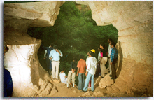 120km east from Goba is one of the most spectacular extensive
cave systems in the world. Created by the Web River in the
limestone rock, the caves are an extraordinary natural
phenomenon and a place of breathtaking beauty. Great caverns
have been carved out of the rock creating soaring underground
chambers. The caves, now an important Islamic shrine, can be
visited with local guides.
120km east from Goba is one of the most spectacular extensive
cave systems in the world. Created by the Web River in the
limestone rock, the caves are an extraordinary natural
phenomenon and a place of breathtaking beauty. Great caverns
have been carved out of the rock creating soaring underground
chambers. The caves, now an important Islamic shrine, can be
visited with local guides.
![]() SHEIKH HUSSSEIN
SHEIKH HUSSSEIN
Located north of Sof Omar, Sheikh Hussein is southern
Ethiopia’s most important center of Muslim pilgrimage and
attracts thousands of pilgrims every year. At least 500 years
old, it’s dedicated to the 13th century holy man (Sheikh
Hussein), who was responsible for the conversation of many
Bale and Arsi Oromo to Islam. Pilgrims came here to make
wishes and to offer thanks for wishes fulfilled.
.